


Thailand
1. Real-time Monitoring Based on Wireless Sensor Networks for Landslide-Prone Areas
A wireless sensor network (WSN) has been developed and tested for collecting environmental parameters such as temperature and humidity. Two communication protocols are tested: ZigBee and LoRa. The structure of the network is shown in Fig. 1.
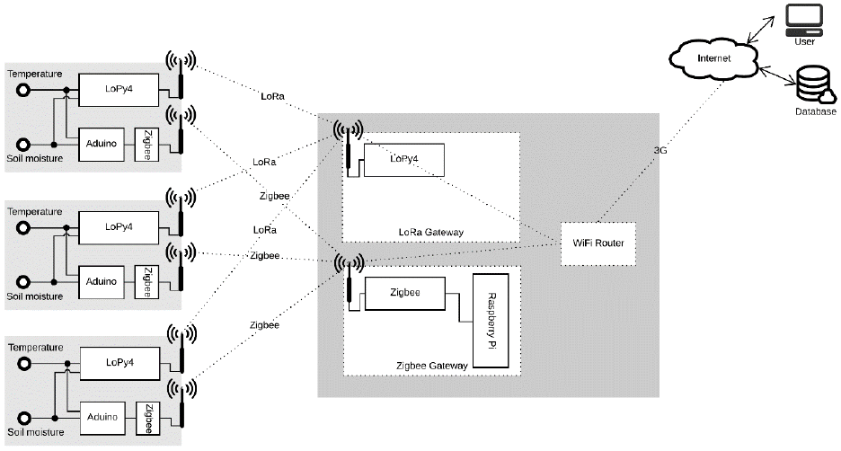 |
| Fig.1 Structure of the wireless sensor network being tested and installed at a landslide-prone area in Chiang Mai, Thailand. |
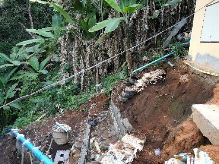
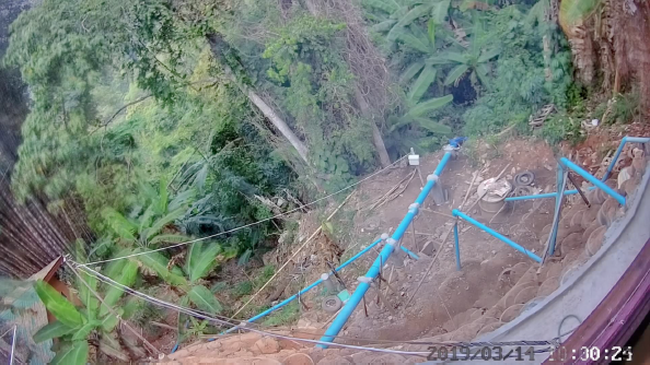
The location at which the network is installed for this testing is Doipui Temple, Chiang Mai, Thailand.
 |
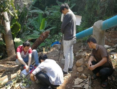 |
| Fig 2. Test site and network installation. | |
Examples of collected data and preliminary data analysis are shown in Fig. 3 and Fig. 4.
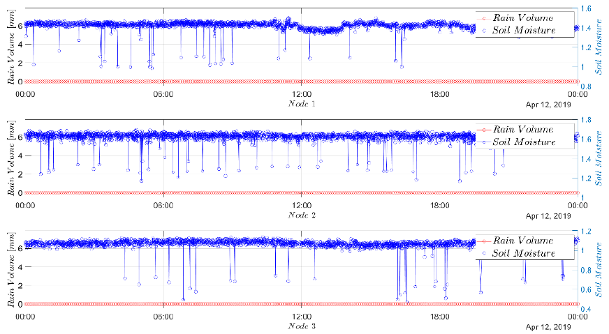 |
| Fig. 3 Example of collected data (Soil moisture). |
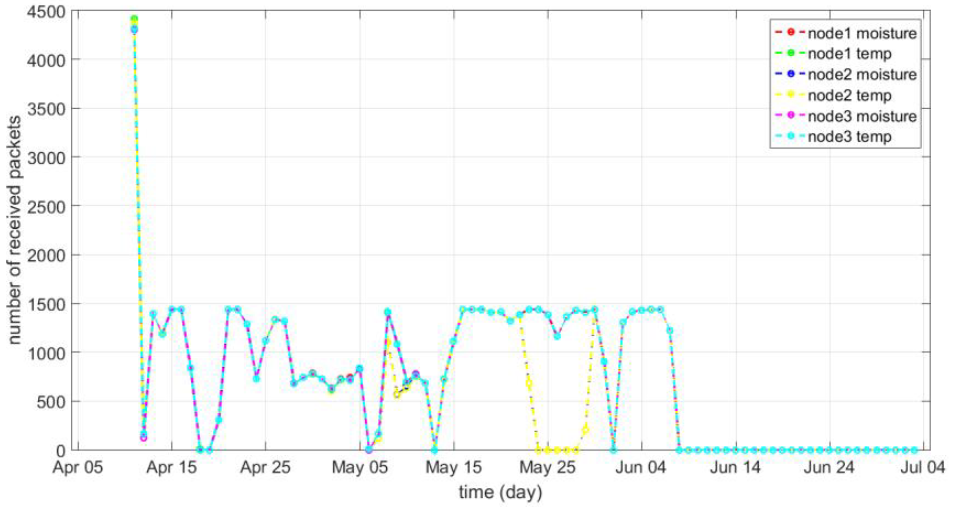 |
| Fig. 4 Example of data analytics: we analyzed the stability of the wireless sensor network in terms of packet losses. |
2. Unsupervised Change Detection in Multi-temporal Satellite Images
The framework of our proposed unsupervised change detection in multi-temporal satellite images is illustrated in Fig. 5 (left). Given two satellite images from different times as the input, the proposed scheme produces a binary map that locates change between them. The binary map is generated based on k-means clustering [1] and structural patch decomposition [2]. Example of resulting images are shown in Fig. 5 (right): the top row shows example satellite images before and after-landslide event. The bottom row shows example images obtained from the PCA-based method [1] and the proposed method.
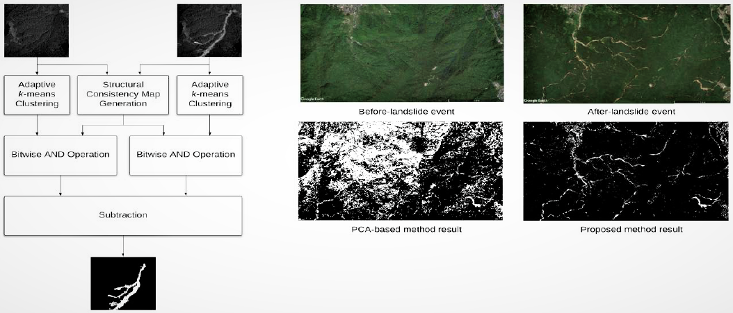 |
| Fig.5 Proposed framework (left) and preliminary results (right). |
Research Gap & Challenges
- Even though the correctness of the proposed method is better than that of the conventional ones, the completeness is somehow poorer. One way to improve the completeness is by enhancing the accuracy of the segmentation algorithm. Thus, we will investigate that part in the course of this project.
- So far, one of the most difficulties in landslide change detection is recognizing clouds and differentiating them from landslide scars. Thus, cloud detection is also proposed to integrate with the main framework.
References
- Celik, T.: Unsupervised change detection in satellite images using principal component analysis and k-means clustering. IEEE Geoscience and Remote Sensing Letters 6(4), 772-776 (2009)
- Ma, K., Li, H., Yong, H., Wang, Z., Meng, D., Zhang, L.: Robust multi-exposure image fusion: a structural patch decomposition approach. IEEE Transactions on Image Processing 26(5), 2519-2532 (2017)
3. Landslide Detection Based on R-CNN
Given a rectangular area of satellite images, the R-CNN identifies landslides’ locations [1]. The R-CNN structure and preliminary results are shown in Fig. 6. In our experiments, the faster R-CNN architecture is as follows. It consists of 188 layers: an image input layer, a convolution 2D layer, a batch normalization layer, a ReLu layer, a max-pooling 2D layer, a global average pooling 2D layer, a fully connected layer, a Softmax layer, a classification output layer, RCNN box regression layer, ROI max-pooling layer, RPN Softmax layer, RPN classification layer, and Region proposal layer.
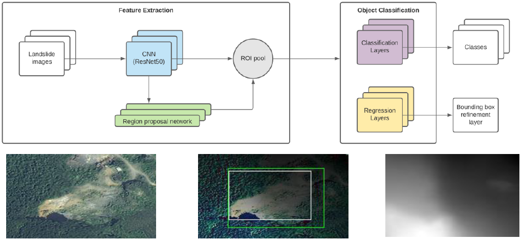 |
| Fig.6 R-CNN architecture used in our experiments (top), preliminary results (bottom-left: input image, bottom-middle: predicted location (green) and ground truth (white)), and a DEM image (bottom-right). |
Research Gap & Challenges
A research gap to be filled during the proposed project is the overall accuracy improvement by applying the following proposed concept. Another R-CNN that takes the digital elevation model (DEM) of the same area is to be constructed. An example of DEM images is shown Figure 5. Then, the predicted locations from both models are combined by using data fusion techniques.
Reference
- Schubert, E., Sander, J., Ester, M., Kriegel, H.P., Xu, X.: DBSCAN revisited, revisited: why and how you should (still) use DBSCAN. ACM Transactions on Database Systems (TODS) 42(3), 1-21 (2017)
4. Surface Displacement Detection from Terrestrial LiDAR Point Clouds
Taking two 3D point clouds from different times as the inputs, the proposed method detects the surface displacement due to, for example, rockfalls. The general steps are image registration, subtraction, clutter removal, and density-based spatial clustering [1] (e.g., DBSCAN [2]).
Research Gap & Challenges
The conventional clutter removal method [3] is based on the k-nearest-neighbor distance, which is time-consumed. A simple but effective approach can replace it to reduce computational time complexity. In addition, most conventional clustering methods consider subtracted images in 2D. In this work, we will investigate the effects when clustering is done in 3D.
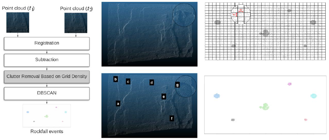 |
| Fig.7 Proposed framework (left), input 3D point clouds (middle; top: before the rockfall events, bottom: after the events), grid-density-based clustering (right-top) and detected rockfall events (right-bottom). |
Reference
- Tonini, M., Abellan, A.: Rockfall detection from terrestrial LiDAR point clouds: A clustering approach using R. Journal of Spatial Information Science 2014(8), 95-110 (2014)
- Ren, S., He, K., Girshick, R., & Sun, J.: Faster R-CNN: Towards real-time object detection with region proposal networks. Advances in Neural Information Processing Systems, 91-99 (2015)
- Byers, S., Raftery, A.E.: Nearest-neighbor clutter removal for estimating features in spatial point processes. Journal of the American Statistical Association 93(442), 577-584 (1998)
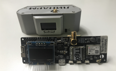
5. Experiments on LoRa Communication Used in a Relay Station Network
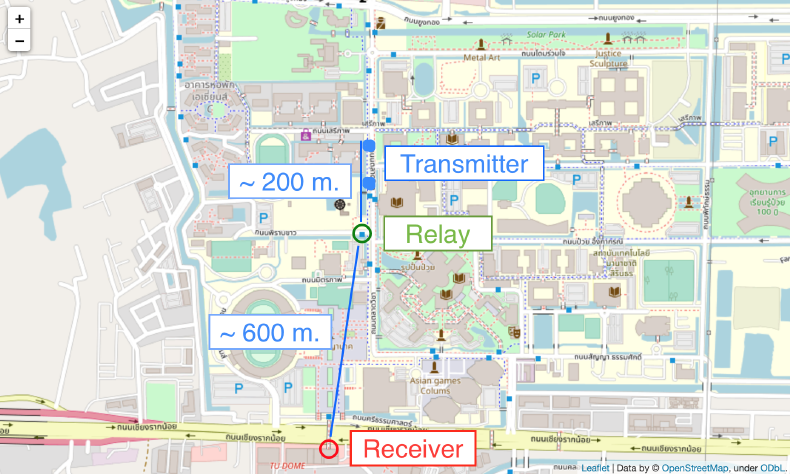
Triggers for a landslide in one area often originate from remotely mountainous or rural areas far away from towns; thus, the 3G/4G system is not available. Therefore, a relay station network based on a low-power wide-area network (LPWAN) technology is proposed to monitor environmental parameters in no-3G-signal landslide-prone areas. The relay station network consists of an array of relay stations whose function is to forward the received data from a monitored area to the next station until the data reach the destination station. Then, the data will be sent to a server via the 3G network from the base station. To achieve the final goal, we initially conduct experiments on multi-hop communication based on the LoRa protocol. This paper aims to report and discuss the implementation of simple LoRa-based relay stations in terms of packet loss and coverage area. In our experiments, each LoRa communication module was set to minimize the communication range first so that the tests could be done within a radius of one kilo-meter in Thammasat University. The scope was limited by setting three parameters: transmission power, coding rate, and bandwidth. Then, a relay function was designed and developed. The performance was evaluated in terms of packet received rate (PRR). The experimental results showed that, for the node-to-node communication with a maximum distance of 600 meters, the PRR was approximately 0.994. When a relay station was added between two nodes, the maximum range, the maximum range extended to 800 meters, with the PRR of 0.795, as shown in Table 1. These results suggest that a higher layer protocol for checking the received packets is necessary.
 |
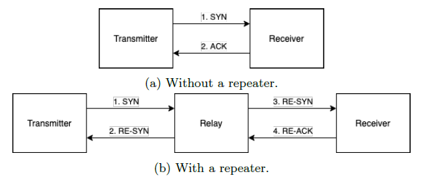 |
| Fig. 8 TTGO T-Beam Board (left) and communication procedures (right). | |
 |
|
| Fig. 9 Locations of the receiver, relay, and transmitter (Thammasat University, Thailand). | |

6. Image Fusion Method with a Visual IoT Camera System
Generating a high-dynamic-range (HDR) image from low-dynamic-range (LDR) images and enhancing the image contrast have been challenge problems in digital image processing since the last few decades. Many techniques, such as multi-exposure fusion [1][2][3] and histogram-based [4], retinex-based [5], and singular value decomposition-based [6][7] contrast enhancement methods, have been proposed to tackle these problems. They play some vital role especially in enhancing the quality of images obtained from a camera of a monitoring system because, in such a system, images captured at different times of a day contain different less-visible areas. It is because they are taken at different directions of the incident ray. As a consequence, shadowed areas of each image are thus different from those of other images. The aim of this work is to investigate a new technique that can be used to generate a representative image of a day from a set of images taken by an NICT’s Visual IoT camera, which is installed at a landslide-prone area. A series of representative images can be useful in analyzing some phenomena relating to landslides, for example, tree tilting which can be used to indicate the mechanisms of slope movement [8].
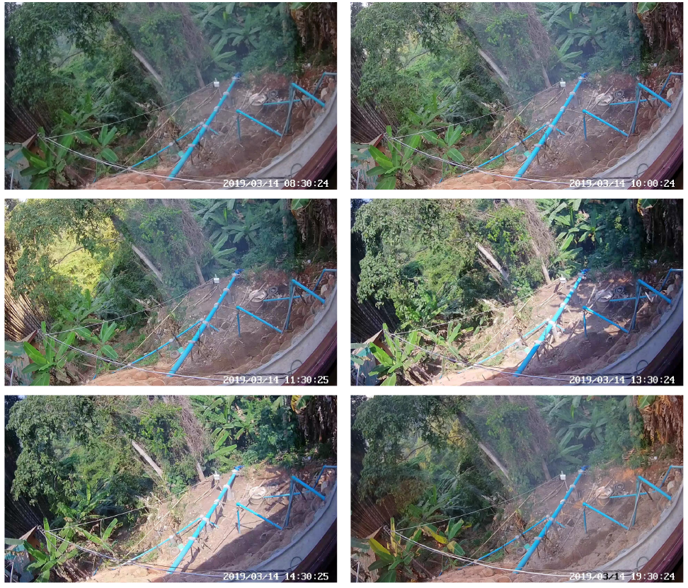 |
| Fig. 10 Input images of the size of 1920×1080. |
 |
| Fig. 11 Resulting image. |
Reference
- Mertens, T., Kautz, J., & Van Reeth, F. (2009, March). Exposure fusion: A simple and practical alternative to high dynamic range photography. In Computer graphics forum (Vol. 28, No. 1, pp. 161-171). Oxford, UK: Blackwell Publishing Ltd.
- Shen, J., Zhao, Y., Yan, S., & Li, X. (2014). Exposure fusion using boosting Laplacian pyramid. IEEE Trans. Cybernetics, 44(9), 1579-1590.
- Ma, K., Li, H., Yong, H., Wang, Z., Meng, D., & Zhang, L. (2017). Robust multi-exposure image fusion: a structural patch decomposition approach. IEEE Transactions on Image Processing, 26(5), 2519-2532.
- Kim, Y. T. (1997). Contrast enhancement using brightness preserving bi-histogram equalization. IEEE transactions on Consumer Electronics, 43(1), 1-8.
- Jobson, D. J., Rahman, Z. U., & Woodell, G. A. (1997). Properties and performance of a center/surround retinex. IEEE transactions on image processing, 6(3), 451-462.
- Bhattacharya, S., Gupta, S., & Subramanian, V. K. (2014, February). Localized image enhancement. In 2014 Twentieth National Conference on Communications (NCC) (pp. 1-6). IEEE.
- Keerativittayanun, S., Kotani, K., Kondo, T., Phatrapornnant, T., & Karnjana, J. (2016, November). Less-visible contrast enhancement based on non-linear scaling function and singular value decomposition. In 2016 International Conference on Digital Image Computing: Techniques and Applications (DICTA) (pp. 1-8). IEEE.
- Šilhán, K. (2015). Can tree tilting indicate mechanisms of slope movement?. Engineering geology, 199, 157-164.
———————————————————————————————————————————
Publications
- Pitisit Dillon, Pakinee Aimmanee, and Jessada Karnjana, “Rockfall Detection from Terrestrial LiDAR Point Clouds by Using DBSCAN with Clutter Removal Based on Grid Density,” The 4th International Conference on Computational Intelligence in Information Systems (CIIS), 2020 [Accepted]
- Asadang Tanatipuknon, Pakinee Aimmanee, Suthum Keerativittayanun, and Jessada Karnjana, “Unsupervised Change Detection in Multi-temporal Satellite Images Based on Structural Patch Decomposition and k-means Clustering for Landslide Monitoring,” The International Symposium on Integrated Uncertainty in Knowledge Modelling and Decision Making (IUKM), 2020 [Accepted]